Kibra Constituency is a distinct administrative unit within Nairobi County, established in 2013 following boundary delineation by the Independent Electoral and Boundaries Commission (IEBC) . It is located southwest of Nairobi’s central business district, it encompasses approximately 12.1 km² and is bordered by Lang’ata Constituency (south/west), Dagoretti North (north), Dagoretti South (northwest), and Starehe (east) .
Kibra at a Glance
| Information | Details |
|---|---|
| Administrative Type | Constituency & Subcounty |
| Year Established | 2013 |
| Parent County | Nairobi |
| Geographic Location | Southwest Nairobi |
| Total Area (sq km) | 12.1 |
| Population (2019 Census) | 185,777 |
| Number of Wards | 5 |
| Administrative Headquarters | Kibra Subcounty Offices |
| Current Representative | |
| Development Fund Allocation |
Administrative Structure
Kibra functions as a single administrative entity serving dual roles as a parliamentary constituency and a subcounty under Kenya’s devolved governance system. The constituency is represented in the National Assembly by MP . Simultaneously, as a subcounty, it is headed by a Deputy County Commissioner (DCC) appointed by the national Ministry of Interior, responsible for coordination national government services and security .
The subcounty shares identical boundaries with the constituency, simplifying administrative reporting to both the Nairobi County Government and national ministries .
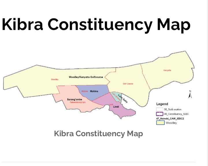
Kibra has 5 wards as follows:
- Sarang’ombe
- Woodley/Kenyatta Golf Course
- Makina
- Laini Saba
- Lindi
Complete Kibra Postal Codes
Kibra utilizes the Nairobi General Post Office (GPO) postal code 00100 for all mail delivery, as Kenya’s postal system assigns codes to post office service areas rather than electoral constituencies .
The Postal Corporation of Kenya (Posta) designates codes based on physical post office locations, and Kibra lacks a dedicated post office branch. Mail is routed through central Nairobi sorting facilities . Residents typically use P.O. Boxes at nearby post offices (e.g., Lang’ata or GPO) for mail receipt. The code structure follows the national format: 0 (Nairobi) + 01 (Central District) + 00 (GPO specific).
| # | Place Name | Type | Location/Ward | Postal Code |
|---|---|---|---|---|
| 1 | Kibera Informal Settlement | Residential Estate | Multiple Wards | 00100 |
| 2 | Ayany Primary School | School | Lindi | – |
| 3 | Olympic Primary School | School | Woodley/Kenyatta GC | – |
| 4 | Toi Market | Shopping Center | Makina | – |
| 5 | Kibra Subcounty Offices | Government Office | Woodley/Kenyatta GC | 00100 |
| 6 | St. Juliet Catholic Church | Religious Institution | Sarang’ombe | – |
| 7 | Woodley Junction | Recreation | Woodley/Kenyatta GC | – |
| 8 | Sarang’ombe | Ward | – | 00100 |
| 9 | Woodley/Kenyatta Golf C. | Ward | – | 00100 |
| 10 | Makina | Ward | – | 00100 |
| 11 | Laini Saba | Ward | – | 00100 |
| 12 | Lindi | Ward | – | 00100 |
| 13 | Kibra Huduma Centre | Government Office | Woodley/Kenyatta GC | – |